
Comparing 23 vendors in 3D Mapping and Modeling - Company Evaluation Report, 2026 across 89 criteria.
The 3D Mapping and Modeling Market is evolving from traditional surveying and static visualization toward advanced reality capture, real-time spatial intelligence, and digital representations of physical environments. 3D mapping involves capturing and analyzing geographic data using technologies such as LiDAR, aerial imagery, photogrammetry, and terrestrial scanning, while 3D modeling focuses on creating digital representations of objects, structures, and environments. These technologies are increasingly essential across construction, infrastructure, transportation, utilities, mining, public safety, and smart city applications. The growing adoption of digital twins, mobile mapping systems, and high-definition mapping solutions is enabling enterprises and government agencies to improve asset management, infrastructure planning, operational efficiency, and data-driven decision-making.
1.1 Study Objectives
1.2 Market Definition
1.2.1 Inclusions and Exclusions
1.3 Market Scope
1.3.1 Market Segmentation
1.3.2 Years Considered
1.4 Currency Considered
1.5 Stakeholders
1.6 Summary of Changes
2.1 Introduction
2.2 Market Dynamics
2.2.1 Drivers
2.2.1.1 Expansion of digital twin deployments across industrial and manufacturing assets
2.2.1.2 Growing adoption of UAV-based reality capture for large-scale geospatial data collection
2.2.1.3 Advancements in AI-powered automated feature extraction and model generation
2.2.1.4 Accelerating investments in autonomous mobility and location-aware systems
2.2.2 Restraints
2.2.2.1 High processing and infrastructure requirements for large-scale 3D datasets
2.2.2.2 Regulatory and airspace restrictions affecting aerial mapping operations
2.2.3 Opportunities
2.2.3.1 Increasing demand for climate resilience, environmental monitoring, and disaster modeling
2.2.3.2 Growing Use of immersive spatial experiences in metaverse and extended reality applications
2.2.3.3 Expansion of indoor digital mapping for smart buildings and facility intelligence
2.2.3.4 Transition from periodic surveys to continuous spatial monitoring
2.2.4 Challenges
2.2.4.1 Maintaining accuracy and consistency across multi-source data acquisition systems
2.2.4.2 Ensuring interoperability across diverse geospatial data formats and software ecosystems
2.3 Unmet Needs and White Spaces
2.3.1 Unmet Needs in 3D Mapping and Modeling Market
2.3.2 White Space Opportunities
2.4 Interconnected Markets and Cross-Sector Opportunities
2.4.1 Interconnected Markets
2.4.2 Cross-Sector Opportunities
2.5 Strategic Moves By Tier-1/2/3 Players
2.6 Evolution of 3D Mapping and Modeling
2.7 Porter’s Five Forces Analysis
2.7.1 Threat of New Entrants
2.7.2 Threat of Substitutes
2.7.3 Bargaining Power of Suppliers
2.7.4 Bargaining Power of Buyers
2.7.5 Intensity of Competitive Rivalry
2.8 Macroeconomic Outlook
2.8.1 Introduction
2.8.2 GDP Trends and Forecast
2.8.3 Trends in Global Convergence of Gis, Bim, Digital Twin & Reality Capture
2.8.4 Trends in Global Digital Twin Solutions Industry
2.8.5 Trends in Global Reality Capture Industry
2.8.6 Trends in Global Infrastructure Intelligence Platforms
2.8.7 Trends in Global Geospatial Ai & Spatial Intelligence
2.8.8 Trends in Global Autonomous Systems & Robotics
2.9 Supply Chain Analysis
2.10 Ecosystem Analysis
2.10.1 Hardware Providers
2.10.1.1 Data capture hardware providers
2.10.1.2 Mapping hardware providers
2.10.1.3 Visualization & computing hardware providers
2.10.2 Software Providers
2.10.2.1 Data capture & processing software providers
2.10.2.2 GIS & spatial analytics software providers
2.10.2.3 Digital twin platform providers
2.10.2.4 Visualization & collaboration platform providers
2.10.3 Service Providers
2.10.3.1 Data capture service providers
2.10.3.2 Modeling & processing service providers
2.10.3.3 Professional service providers
2.10.3.4 Managed service providers
3.1 Overview
3.2 Key Player Competitive Strategies, 2022–2026
3.3 Revenue Analysis, 2021–2025
3.4 Market Share Analysis, 2025
3.4.1 Market Ranking Analysis, 2025
3.5 Product Comparison
3.5.1 Comparative Analysis of 3D Mapping and Modeling Digital Twin Platforms
3.5.1.1 Trimble (Trimble Connect/Trimble Reality Capture Platform)
3.5.1.2 Autodesk (Autodesk Tandem)
3.5.1.3 Hexagon AB (HxDR/HxGN Digital Reality Platform)
3.5.1.4 Bentley Systems (iTwin Platform)
3.5.1.5 CoStar Group/Matterport (Matterport Digital Twin Platform)
3.5.2 Comparative Analysis of 3D Mapping and Modeling Hardware (Mobile Mapping System)
3.5.2.1 Trimble (Trimble MX90 Mobile Mapping System)
3.5.2.2 Topcon (Topcon IP-S3 HD1 Mobile Mapping System)
3.5.2.3 Hexagon (Leica Pegasus TRK Mobile Mapping System)
3.5.2.4 Teledyne (Teledyne Optech CL-360 Mobile Mapping System)
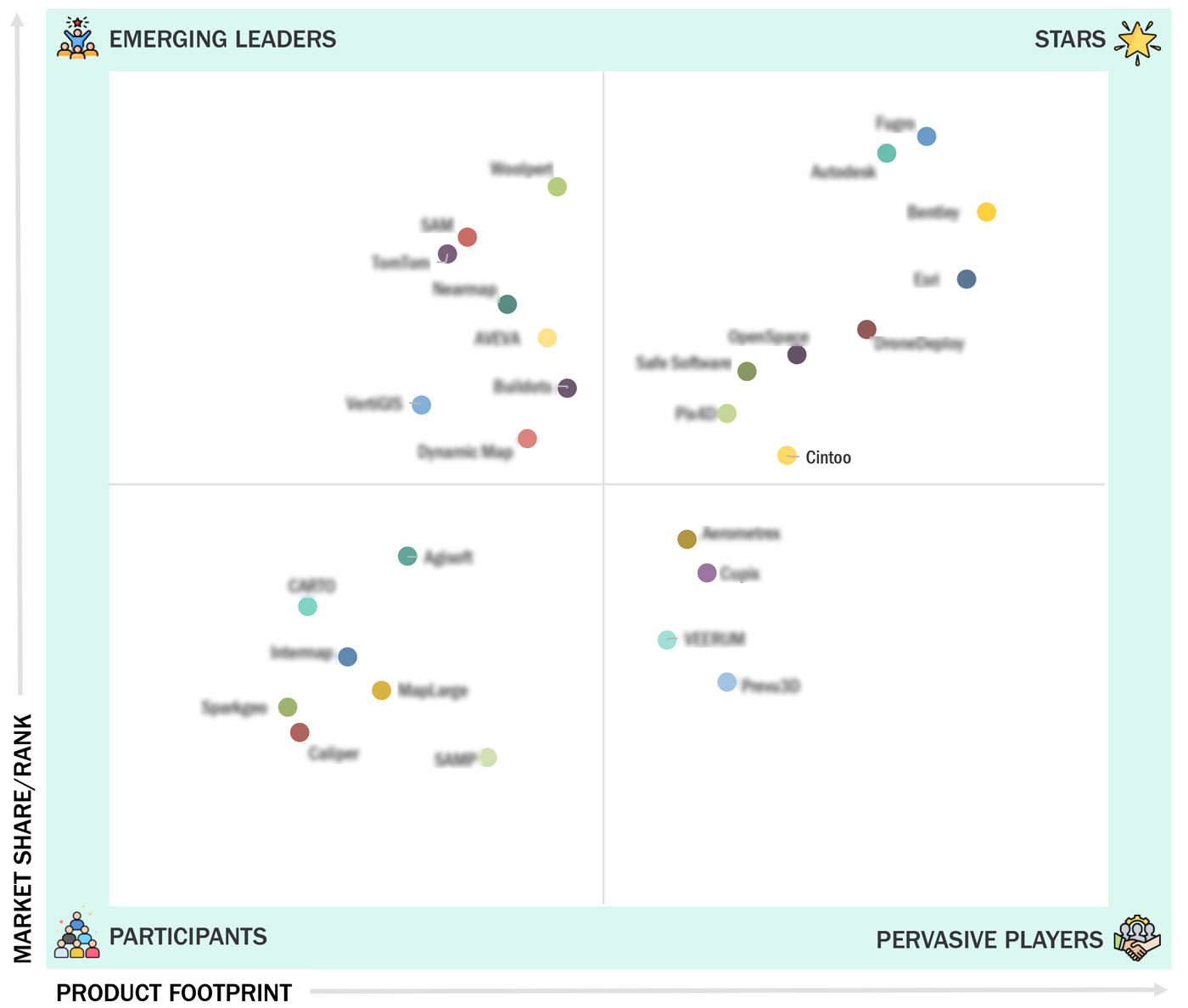
3.7 Company Evaluation Matrix (Software Providers)
3.7.1 Stars
3.7.2 Emerging Leaders
3.7.3 Pervasive Players
3.7.4 Participants
3.7.5 Company Footprint: 3D Mapping and Modeling Market: Software Providers
3.7.5.1 Company footprint: (Software providers)
3.7.5.2 Regional footprint (Software providers)
3.7.5.3 Offering footprint (Software providers)
3.7.5.4 Organization size footprint (Software providers)
3.7.5.5 Vertical footprint (Software providers)
3.8 Company Valuation and Financial Metrics
3.9 Competitive Scenario
3.9.1 Product Launches and Enhancements
3.9.2 Deals
4.1 AUTODESK, INC.
4.1.1 Business overview
4.1.2 Products/Solutions/Services offered
4.1.3 Recent developments
4.2 FUGRO
4.2.1 Business overview
4.2.2 Products/Solutions/Services offered
4.2.3 Recent developments
4.3 BENTLEY SYSTEMS, INCORPORATED
4.3.1 Business overview
4.3.2 Products/Solutions/Services offered
4.3.3 Recent developments
4.4 ESRI
4.4.1 Business overview
4.4.2 Products/Solutions/Services offered
4.4.3 Recent developments
4.5 WOOLPERT
4.5.1 Business overview
4.5.2 Products/Solutions/Services offered
4.5.3 Recent developments
4.6 SAM
4.6.1 Business overview
4.6.2 Products/Solutions/Services offered
4.6.3 Recent developments
4.7 TOMTOM INTERNATIONAL B.V.
4.7.1 Business overview
4.7.2 Products/Solutions/Services offered
4.7.3 Recent developments
4.8 DRONEDEPLOY
4.8.1 Business overview
4.8.2 Products/Solutions/Services offered
4.8.3 Recent developments
4.9 SAFE SOFTWARE
4.9.1 Business overview
4.9.2 Products/Solutions/Services offered
4.9.3 Recent developments
4.10 PIX4D
4.10.1 Business overview
4.10.2 Products/Solutions/Services offered
4.10.3 Recent developments
4.11 OPENSPACE
4.11.1 Business overview
4.11.2 Products/Solutions/Services offered
4.11.3 Recent developments
4.12 CINTOO
4.12.1 Business overview
4.12.2 Products/Solutions/Services offered
4.12.3 Recent developments
4.13 CUPIX
4.13.1 Business overview
4.13.2 Products/Solutions/Services offered
4.13.3 Recent developments
4.14 MAPLARGE
4.14.1 Business overview
4.14.2 Products/Solutions/Services offered
4.14.3 Recent developments
4.15 AEROMETREX
4.15.1 Business overview
4.15.2 Products/Solutions/Services offered
4.15.3 Recent developments
4.16 NEARMAP
4.16.1 Business overview
4.16.2 Products/Solutions/Services offered
4.16.3 Recent developments
4.17 VERTIGIS
4.17.1 Business overview
4.17.2 Products/Solutions/Services offered
4.17.3 Recent developments
4.18 CARTO
4.18.1 Business overview
4.18.2 Products/Solutions/Services offered
4.18.3 Recent developments
4.19 DYNAMIC MAP PLATFORM
4.19.1 Business overview
4.19.2 Products/Solutions/Services offered
4.19.3 Recent developments
4.20 INTERMAP TECHNOLOGIES
4.20.1 Business overview
4.20.2 Products/Solutions/Services offered
4.20.3 Recent developments
4.21 AGISOFT
4.21.1 Business overview
4.21.2 Products/Solutions/Services offered
4.21.3 Recent developments
4.22 CALIPER CORPORATION
4.22.1 Business overview
4.22.2 Products/Solutions/Services offered
4.22.3 Recent developments
4.23 SPARKGEO
4.23.1 Business overview
4.23.2 Products/Solutions/Services offered
4.23.3 Recent developments


Company Profiles
Strategy, financials, growth, and SWOT
Market Insights
Visual quadrant of competitors and leaders
Benchmarking
Compare by product, region, and end-user
Lead Gen Add-on
Use the quadrant to attract clients
 TipRanks
 Sep 2026
TradingView
Feb 2026
Autodesk, Inc.
Oct 2026
Autodesk
Sep 2026
Autodesk, Inc.
Sep 2026

360 Quadrants is a scientific research methodology by MarketsandMarkets to understand market leaders in 6000+ micro markets
360 Quadrants is a scientific research methodology by MarketsandMarkets to understand market leaders in 6000+ micro markets
Email : [email protected]
Quick Links
360 Quadrants is a scientific research methodology by MarketsandMarkets to understand market leaders in 6000+ micro markets
 Company
 Headquarters
 Year Founded
 Holding Type