Comparing 17 vendors in Geospatial Imagery Analytics Startups across 0 criteria.
1.1 Study Objectives
1.2 Market Definition and Scope
1.2.1 Inclusions and Exclusions
1.3 Market Scope
1.3.1 Market Segmentation
1.3.2 Years Considered
1.4 Currency Considered
1.5 Stakeholders
1.6 Summary of Changes
2.1 Introduction
2.2 Market Dynamics
2.2.1 Drivers
2.2.1.1 Proliferation of satellite and UAV imagery
2.2.1.2 Growing adoption of location-based services across
industries
2.2.1.3 Increasing industry-specific Use cases
2.2.1.4 Advancements in AI/ML & cloud computing
2.2.2 Restraints
2.2.2.1 Data privacy and security concerns
2.2.2.2 Regulatory barriers restricting scalable access to
geospatial data
2.2.2.3 Complexities in integration and standardization of
geospatial data
2.2.3 Opportunities
2.2.3.1 Climate monitoring and ESG reporting
2.2.3.2 Expansion of commercial satellite constellations
2.2.3.3 Customization and on-demand analytics services
2.2.4 Challenges
2.2.4.1 Temporal and spatial resolution tradeoffs
2.2.4.2 Quality and accuracy variability
2.3 Impact of US Tariff – Geospatial Imagery Analytics Market
2.3.1 Introduction
2.3.2 Key Tariff Rates
2.3.3 Price Impact Analysis
2.3.3.1 Strategic shifts and emerging trends
2.3.4 Impact on Country/Region
2.3.4.1 US
2.3.4.1.1 Strategic shifts and key observations
2.3.4.2 China
2.3.4.2.1 Strategic shifts and key observations
2.3.4.3 Southeast Asia
2.3.4.3.1 Strategic shifts and key observations
2.3.4.4 Europe
2.3.4.4.1 Strategic shifts and key observations
2.3.5 Impact on End-Use Industries
2.3.5.1 Agriculture and Precision Farming
2.3.5.2 Infrastructure & Urban Planning
2.3.5.3 Defense and Intelligence
2.3.5.4 Environmental Monitoring & Disaster Management
2.3.5.5 Oil, Gas, and Mining
2.4 Evolution of Geospatial Imagery Analytics Market
2.5 Supply Chain Analysis
2.6 Ecosystem Analysis
2.6.1 Image Processing & Enhancement
2.6.2 Object Tracking & Feature Detection
2.6.3 Change Detection & Time-Series Analysis
2.6.4 Predictive Modeling & Pattern Recognition
2.6.5 AI/Ml-Based Geospatial Analytics
2.6.6 Others (Anomaly Detection and Stream Analytics)
2.7 Investment Landscape and Funding Scenario
2.8 Impact of Generative AI on Geospatial Imagery Analytics Market
2.8.1 Super-Resolution Image Enhancement
2.8.2 Synthetic Data Generation for Model Training
2.8.3 Automatic Feature Extraction and Mapping
2.8.4 Change Detection and Temporal Analysis
2.8.5 Disaster Scenario Simulation and Risk Assessment
2.8.6 Augmented Reality (Ar) and Visualization for Geospatial Data
2.9 Technology Analysis
2.9.1 Key Technologies
2.9.1.1 Remote Sensing
2.9.1.2 Machine Learning
2.9.1.3 Georeferencing
2.9.1.4 Photogrammetry
2.9.2 Complementary Technologies
2.9.2.1 Edge Computing
2.9.2.2 5G
2.9.2.3 Cloud Computing
2.9.3 Adjacent Technologies
2.9.3.1 Digital Twin Technology
2.9.3.2 Autonomous Navigation
2.9.3.3 Internet of Things (IoT)
2.9.3.4 Blockchain
2.10 Patent Analysis
2.10.1 Methodology
2.10.2 Patents Filed, By Document Type
2.10.3 Innovation and Patent Applications
2.11 Key Conferences and Events (2025–2026)
2.12 Porter’s Five Forces Analysis
2.12.1 Threat of New Entrants
2.12.2 Threat of Substitutes
2.12.3 Bargaining Power of Suppliers
2.12.4 Bargaining Power of Buyers
2.12.5 Intensity of Competitive Rivalry
2.13 Trends/Disruptions Impacting Customers’ Businesses
2.14 Key Stakeholders & Buying Criteria
2.14.1 Key Stakeholders in Buying Process
2.14.2 Buying Criteria
3.1 Overview
3.2 Key Player Strategies/Right to Win, 2022–2025
3.3 Revenue Analysis, 2020–2024
3.4 Market Share Analysis, 2024
3.4.1 Market Ranking Analysis
3.5 Product Comparative Analysis
3.5.1 Maxar Earth Intelligence (Maxar Technologies)
3.5.2 Planetscope/Skysat (Planet Labs)
3.5.3 Spectra AI (Blacksky)
3.5.4 Capella Analytics (Capella Space)
3.5.5 Google Earth Engine (Google)
3.6 Company Valuation and Financial Metrics
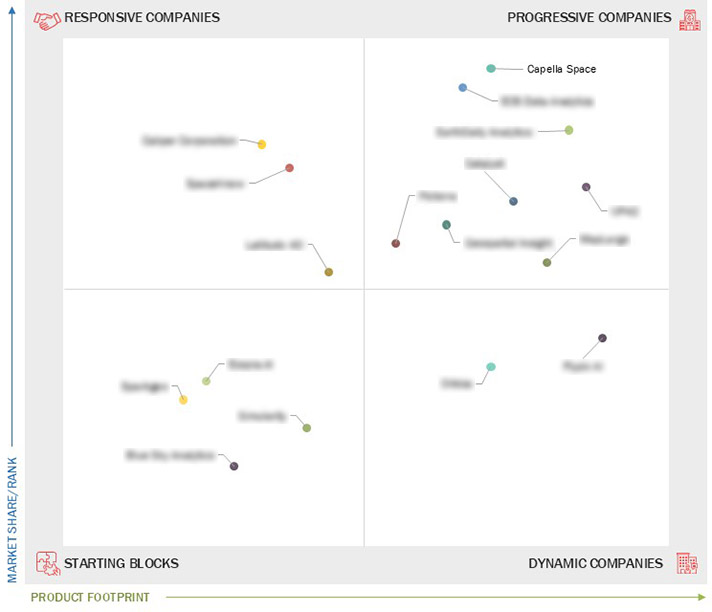
3.7 Company Evaluation Matrix: Startups/SMEs, 2024
3.7.1 Progressive Companies
3.7.2 Responsive Companies
3.7.3 Dynamic Companies
3.7.4 Starting Blocks
3.7.5 Competitive Benchmarking: Startups/SMEs, 2024
3.7.5.1 Detailed list of key startups/SMEs
3.7.5.2 Competitive benchmarking of key startups/SMEs
3.8 Competitive Scenario and Trends
3.8.1 Product Launches and Enhancements
3.8.2 Deals
4.1 EARTHDAILY ANALYTICS
4.1.1 Business overview
4.1.2 Products/Solutions/Services offered
4.1.3 Recent developments
4.2 SPARKGEO
4.2.1 Business overview
4.2.2 Products/Solutions/Services offered
4.2.3 Recent developments
4.3 ORBICA
4.3.1 Business overview
4.3.2 Products/Solutions/Services offered
4.3.3 Recent developments
4.4 CALIPER CORPORATION
4.4.1 Business overview
4.4.2 Products/Solutions/Services offered
4.4.3 Recent developments
4.5 MAPLARGE
4.5.1 Business overview
4.5.2 Products/Solutions/Services offered
4.5.3 Recent developments
4.6 BLUE SKY ANALYTICS
4.6.1 Business overview
4.6.2 Products/Solutions/Services offered
4.6.3 Recent developments
4.7 LATITUDO 40
4.7.1 Business overview
4.7.2 Products/Solutions/Services offered
4.7.3 Recent developments
4.8 CAPELLA SPACE
4.8.1 Business overview
4.8.2 Products/Solutions/Services offered
4.8.3 Recent developments
4.9 ECOPIA.AI
4.9.1 Business overview
4.9.2 Products/Solutions/Services offered
4.9.3 Recent developments
4.10 EOS DATA ANALYTICS
4.10.1 Business overview
4.10.2 Products/Solutions/Services offered
4.10.3 Recent developments
4.11 CATALYST
4.11.1 Business overview
4.11.2 Products/Solutions/Services offered
4.11.3 Recent developments
4.12 SPACEKNOW
4.12.1 Business overview
4.12.2 Products/Solutions/Services offered
4.12.3 Recent developments
4.13 FLYPIX AI
4.13.1 Business overview
4.13.2 Products/Solutions/Services offered
4.13.3 Recent developments
4.14 PICTERRA
4.14.1 Business overview
4.14.2 Products/Solutions/Services offered
4.14.3 Recent developments
4.15 GEOSPATIAL INSIGHT
4.15.1 Business overview
4.15.2 Products/Solutions/Services offered
4.15.3 Recent developments
4.16 UP42
4.16.1 Business overview
4.16.2 Products/Solutions/Services offered
4.16.3 Recent developments
4.17 SIMULARITY
4.17.1 Business overview
4.17.2 Products/Solutions/Services offered
4.17.3 Recent developments
Company Profiles
Strategy, financials, growth, and SWOTMarket Insights
Visual quadrant of competitors and leadersBenchmarking
Compare by product, region, and end-userLead Gen Add-on
Use the quadrant to attract clients SatNews Publishers
 Aug 2025
spacenews
May 2025
spacenews
May 2025
businesswire
Sep 2024
Aug 2025
spacenews
May 2025
spacenews
May 2025
businesswire
Sep 2024
![]()
360 Quadrants is a scientific research methodology by MarketsandMarkets to understand market leaders in 6000+ micro markets
360 Quadrants is a scientific research methodology by MarketsandMarkets to understand market leaders in 6000+ micro markets
Email : [email protected]
Quick Links ![]()
360 Quadrants is a scientific research methodology by MarketsandMarkets to understand market leaders in 6000+ micro markets