
Geographic Information System (GIS) Quadrant Report
Geographic Information System Market (Global) Company Evaluation Quadrant
Published on
Feb'2020
Pages
57
Code
360-SE 5492
A geographic information system is an intelligent tool that is used for data capturing, mapping, analyzing, and visualizing spatial data. Various types of GIS tools are used according to the feasibility and application area. Desktop GIS software is commonly used for performing functions such as mapping, data analysis, map creation, and data conflation. Web GIS provides a cloud platform composed of data handling tools for storage, recovery, management, and the study of spatial data.
The geographic information system market is valued at USD 8 billion in 2020 and is projected to reach USD 15 billion by 2025. It is expected to grow at a CAGR of 12.4% from 2020 to 2025. A few of the major driving factors for the growth of this market include the development of smart cities and urbanization, integration of geospatial technology with mainstream technologies for business intelligence, and growing adoption of GIS solutions in the transportation sector.
Adoption of GIS solutions in the transportation sector and development of smart cities and urbanization to drive this market
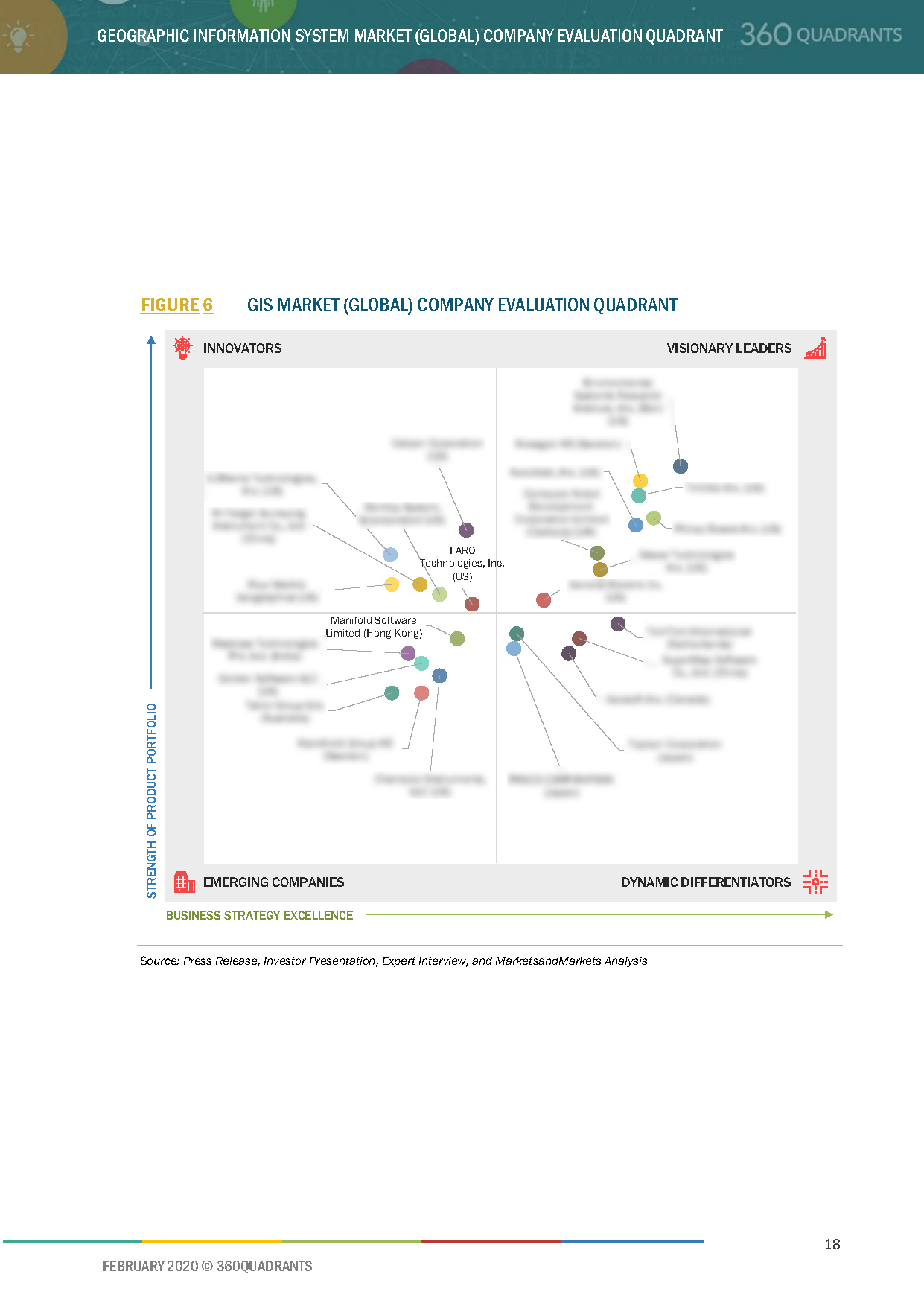
Few leading players in the Geographic Information System Market are Esri, Hexagon, Pitney Bowes, Trimble, and Autodesk. These best geographic information system providers are rated and positioned on 2x2 matrix, called as ‘Company Evaluation Quadrant,’ and identified as: Visionary Leaders, Dynamic Differentiators, Innovators, and Emerging companies.
The report includes market-specific company profiles of 20 best geographic information system providers and assesses the recent developments that shape the competitive landscape of this highly fragmented market.
List of top geographic information system companies evaluated and profiled in the report:
- AUTODESK INC.
- BENTLEY SYSTEM, INC.
- BLUE MARBLE GEOGRAPHICS
- CALIPER CORPORATION
- COMPUTER AIDED DEVELOPMENT CORPORATION LIMITED
- ENVIRONMENTAL SYSTEMS RESEARCH INSTITUTE, INC.
- FARO TECHNOLOGIES
- GENERAL ELECTRIC
- HEXAGON AB
- HI-TARGET SURVEYING INSTRUMENT CO.
- L3HARRIS TECHNOLOGIES
- MAPTOSS TECHNOLOGIES
- MAXAR TECHNOLOGIES INC.
- PASCO CORP
- PITNEY BOWES INC.
- SUPERMAP SOFTWARE
- TAKOR GROUP
- TOMTOM INTERNATIONAL
- TOPCON CORPORATION
- TRIMBLE INC.
Table of Contents
1 Introduction
1.1 Market Definition and Scope
1.1.1 Inclusions & Exclusions
2 Market Overview
2.1 Introduction
2.2 Market Dynamics
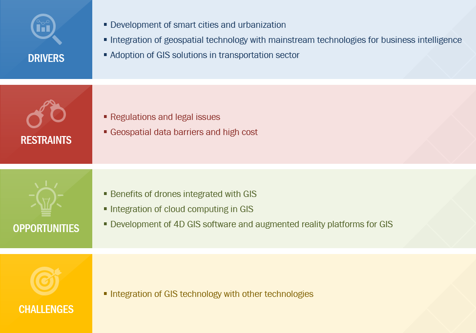
Figure 1 Geographic Information System Market: Drivers, Restraints, Opportunities, and Challenges
2.2.1 Drivers
2.2.1.1 Development of Smart Cities and Urbanization
2.2.1.2 Integration of Geospatial Technology With Mainstream Technologies for Business Intelligence
2.2.1.3 Adoption of GIS Solutions in Transportation Sector
Figure 2 GIS Market Drivers and Their Impact
2.2.2 Restraints
2.2.2.1 Regulations and Legal Issues
2.2.2.2 Geospatial Data Barriers and High Cost
2.2.3 Opportunities
2.2.3.1 Benefits of Drones Integrated With GIS
2.2.3.2 Integration of Cloud Computing in GIS
2.2.3.3 Development of 4D GIS Software and Augmented Reality Platforms for GIS
Figure 3 GIS Market Opportunities and Their Impact
2.2.4 Challenges
2.2.4.1 Integration of GIS Technology With Other Technologies
Figure 4 GIS Market Restraints & Challenges and Their Impact
3 Industry Trends
3.1 Introduction
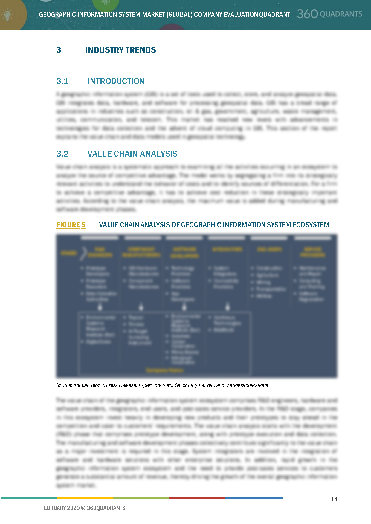
3.2 Value Chain Analysis
Figure 5 Value Chain Analysis of Geographic Information System Ecosystem
3.3 GIS Data
3.3.1 Types of GIS Data Models
3.3.1.1 Vector Data Model
3.3.1.2 Raster Data Model
3.4 Trends in GIS Market
3.4.1 AR and VR Technologies
3.4.2 Unmanned Aerial Vehicles
4 Company Evaluation Quadrant
4.1 Visionary Leaders
4.2 Innovators
4.3 Dynamic Differentiators
4.4 Emerging Companies
Figure 6 GIS Market (Global) Company Evaluation Quadrant
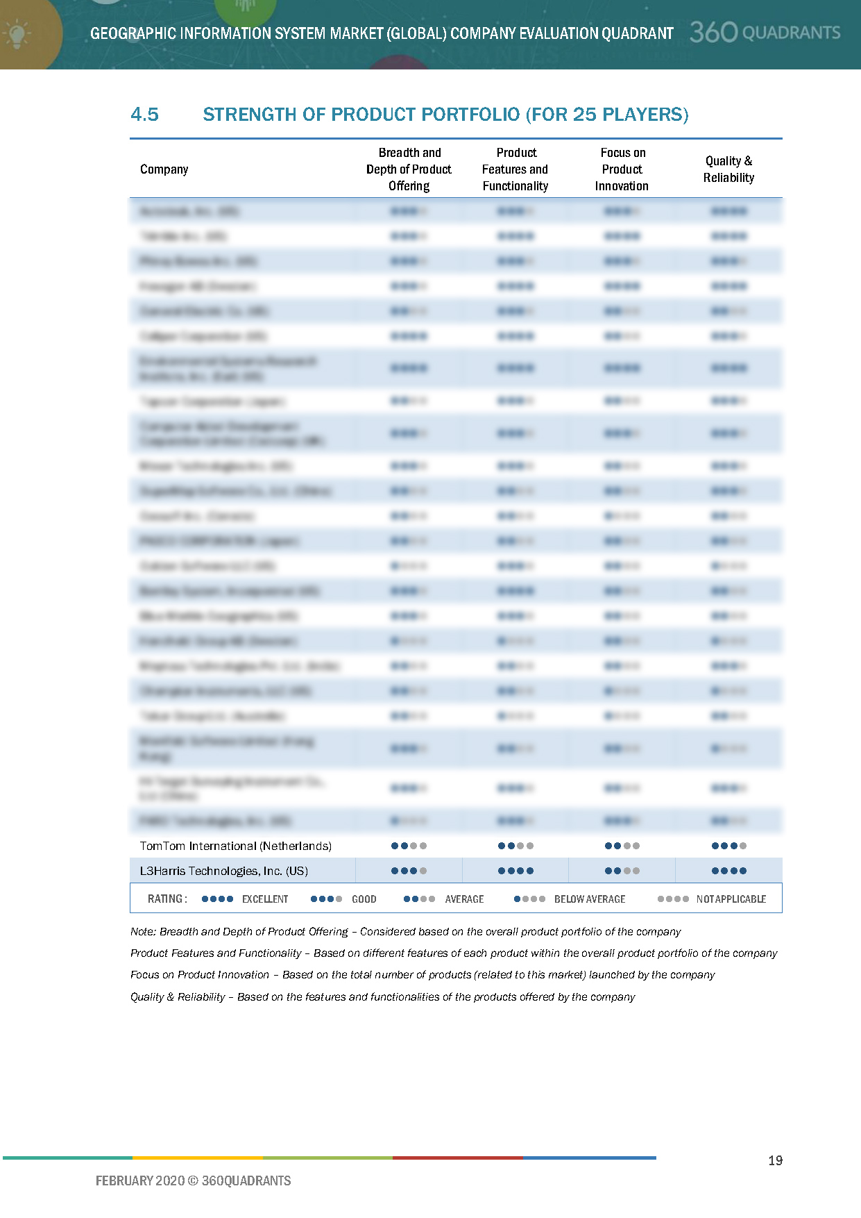
4.5 Strength of Product Portfolio (For 25 Players)
4.6 Business Strategy Excellence (For 25 Players)
5 Competitive Landscape
5.1 Introduction
Figure 7 Key Growth Strategies Adopted By Companies from 2018 to 2020
5.2 Market Ranking Analysis
Figure 8 Ranking of Key Players in GIS Software Market, 2019
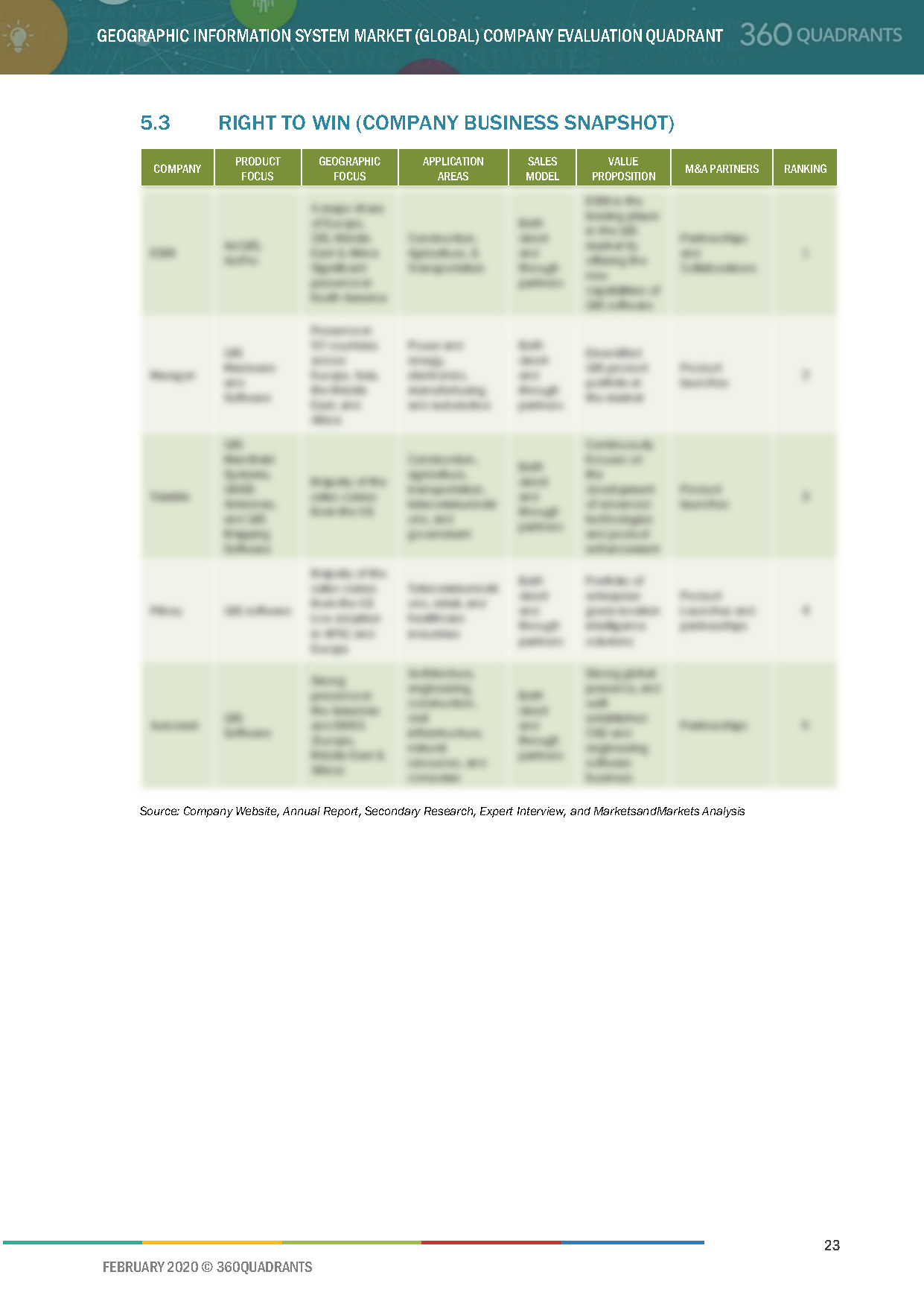
5.3 Right to Win (Company Business Snapshot)
5.4 Competitive Scenario
5.4.1 Product Launches and Product Developments
Table 1 Product Launches & Product Developments, 2018–2020
5.4.2 Mergers, Acquisitions, Partnerships, and Collaborations
Table 2 Mergers, Acquisitions, Partnerships, and Collaborations, 2018–2020
6 Company Profiles
6.1 Introduction
6.2 Key Players
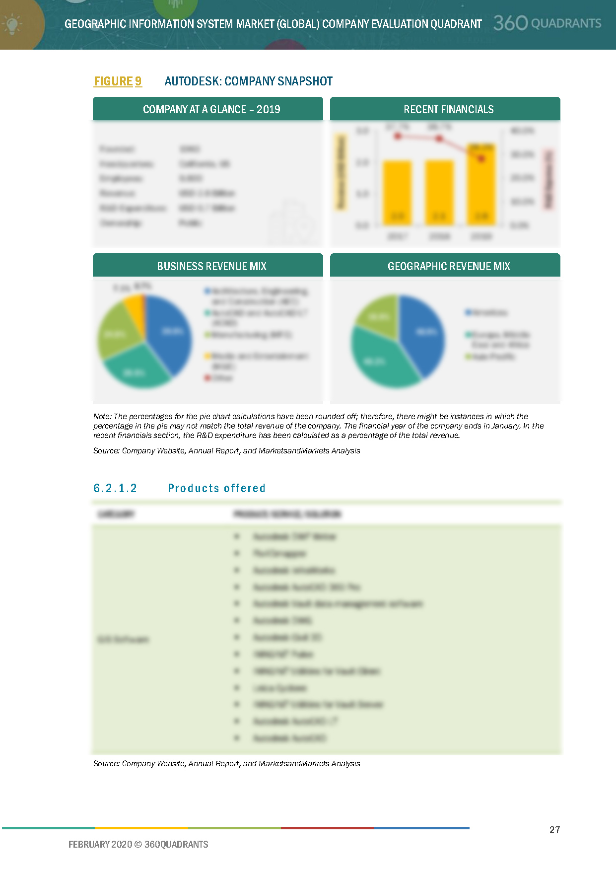
6.2.1 Autodesk
6.2.1.1 Business Overview*
Figure 9 Autodesk: Company Snapshot
6.2.1.2 Products Offered*
6.2.1.3 Recent Developments*
6.2.1.4 SWOT Analysis*
6.2.1.5 MnM View*
(*Above sections are present for all of below companies)
6.2.2 Esri
6.2.3 Trimble
Figure 10 Trimble: Company Snapshot
6.2.4 Pitney Bowes
Figure 11 Pitney: Company Snapshot
6.2.5 Hexagon
Figure 12 Hexagon: Company Snapshot
6.2.6 Topcon
Figure 13 Topcon: Company Snapshot
6.2.7 Maxar Technologies
Figure 14 Maxar Technologies: Company Snapshot
6.2.8 Caliper Corporation
6.2.9 Bentley Systems
7 Appendix
7.1 Other Significant Players
7.1.1 TomTom International
7.1.2 SuperMap Software
7.1.3 General Electric
7.1.4 FARO Technologies
7.1.5 L3Harris Technologies
7.1.6 Takor Group
7.1.7 Maptoss Technologies
7.1.8 Computer Aided Development Corporation Limited (Cadcorp)
7.1.9 Hi-Target Surveying Instrument
7.1.10 Blue Marble Geographics
7.1.11 PASCO CORPORATION
7.2 Methodology
This report identifies and benchmarks the key market players such as Esri, Hexagon, Pitney Bowes, Trimble, and Autodesk, and evaluates them on the basis of business strategy excellence and strength of product portfolio within the geographic information system ecosystem, combining inputs from various industry experts, buyers, and vendors, and extensive secondary research including annual reports, company press releases, investor presentations, free and paid company databases. They are rated and positioned on a 2x2 matrix, called as ‘Company Evaluation Quadrant,’ and identified as Visionary Leaders, Dynamic Differentiators, Innovators, or Emerging companies.
SAMPLES:
Personalize Your Research Requirement
- Updated version of this Quadrant
- Different Company Evaluation Quadrant
- 'Startup Only' Company Evaluation Quadrant
- Region or Country specific evaluation
- Application or Industry specific evaluation ..Read More
Analyst Briefing & Inquiry
- Submit a Briefing Request
- Question about our published research
- Request for evaluation of your organization for specific market
- Request for re-evaluation of Company Evaluation Quadrant ..Read More
